

Hoping to collect more information about the biggest, wettest storms that soak California each year — filling reservoirs and also causing damaging floods — a coalition of Bay Area water agencies on Thursday unveiled its completed $19.7 million system of high-tech radar stations that stretches from Sonoma County to Santa Cruz.
The network features six radar installations in Contra Costa, San Mateo, Santa Clara, Santa Cruz, Marin and Sonoma counties that can track storms with faster and higher-resolution updates than the current National Weather Service radar stations.
The system is the culmination of 15 years of work between Bay Area government agencies and the first of its kind in the state, said Sonoma Water General Manager Grant Davis.
“This is a response to the huge challenge we’ve been facing,” Davis said, noting the heavy fallout of megastorms known as atmospheric rivers, which have done more damage in Sonoma County over the past four decades than any other place in the western United States.
“We’re really ground zero here,” Davis said Friday, standing aside his agency’s radar array near the Sonoma County airport.
In a typical year, California receives about a dozen big atmospheric river storms — huge conveyor belts of moisture that account for roughly 50% of the state’s annual precipitation. In the coastal mountains that drain into the Russian River, the storms can delivery heavy runoff and unleash surging floodwaters, landslides and other mayhem.
The old radar systems, which scan above 5,000 feet, can miss these intense local bursts that often occur closer to the ground, experts said. But the new radar facilities can track them, providing more accurate, timely information to forecasters and local emergency officials.
“Storms that hit the Bay Area come in off the ocean, where there is not much data,” said Marty Ralph, director of the Center for Western Weather and Water Extremes at UC San Diego’s Scripps Institution of Oceanography. “They hit mountains and urban areas, and it makes for a lot of complications in finding out where and when the heaviest rain will fall.”
The upgraded radar network— known as Advanced Quantitative Precipitation Information, or AQPI — has been under development, construction and testing since 2018, and is the first of its kind in the state.
“This radar can monitor the details of storms in ways that have never been done before,” Ralph said. “It will provide information hours ahead to help people who manage water, transportation and wastewater.”
Funding for the project came from the state Department of Water Resources.
Five of the radar stations are called “X-band” radar. They offer more precise, detailed images than the “S-band” systems the National Weather Service has atop Mount Umunhum south of San Jose and in Sacramento.
The new radar stations also provide updated images every one to two minutes, instead of every five to seven minutes. And most importantly, they are able to measure storm events that are below 5,000 feet, when the S-band radar mostly tracks weather systems above that.
“You get a much more granular picture of where rain is hitting, when it is going to hit, for how long, and the intensity,” Davis said.
“There are low-lying areas across the Bay Area in which flooding is likely to occur,” Davis said. “Emergency officials need to make a decision many hours ahead. This radar network helps them plan.”
The system has been put together one station at a time over the past eight years by a partnership between Colorado State University, UC San Diego, and the National Oceanic and Atmospheric Administration.
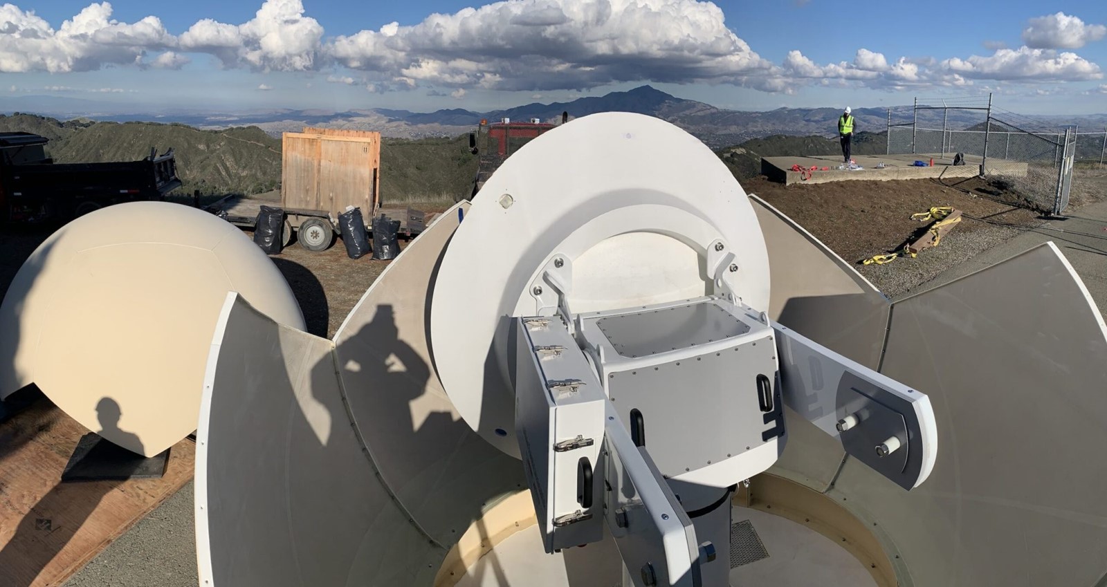
The five X-band radar stations are each about the size of a small shed. They include a radar dish protected by a large, round protective cover.
Sonoma County’s X-band station, at the end of Aviation Boulevard near the airport, was installed in 2019 and updated in 2023.
The other four are located at Sawyer Ridge in San Mateo County west of Crystal Springs Reservoir; atop the Santa Clara Valley Water District’s Penitencia Water Treatment Plant in San Jose; on Rocky Ridge in Contra Costa County; and atop the Santa Cruz County Government Center in Santa Cruz. Each of those came online at different times in recent years.
Davis noted that the system was used to track a tornado that touched down in December 2024 in Scotts Valley, near Santa Cruz, and to help monitor storms in the flood-prone Russian River area in Sonoma County.
The sixth and final radar facility, a larger C-band system, is located on Barnabe Mountain in Marin County, about 3 miles east of Point Reyes National Seashore. It received an FCC license at the beginning of this month and will be online in the next few days. That radar station helps track storms as they approach the coast and complements the X-band radars by providing a broader view of incoming systems before they move inland, experts said Thursday.
“We are essentially filling gaps in coverage with these radars,” said John Rutz, an atmospheric scientist with the Center for Western Weather and Water Extremes at UC San Diego’s Scripps Institution of Oceanography. “It’s like putting glasses on and being able to see in much more detail.”
The six radars are currently operated by the Cooperative Institute for Research in the Atmosphere at Colorado State University. Starting July 1, 2026, Scripps will lead and manage the system.
The new radar system can also track smoke from wildfires and provide more detailed information about typical rainstorms, improving the accuracy of forecasts.
Understanding more about how much water each storm system is delivering can also help water managers operate reservoirs. If they know a large storm is coming, they can release more water to make space in a full reservoir, reducing flood risk. If the storm is going to miss the area, they can release less, saving more water for dry times. That is particularly important as climate change makes droughts more severe and can also increase the amount of moisture in atmospheric river storms.
“We have to get the most out of each storm that comes across California,” said Mike Anderson, state climatologist with the California Department of Water Resources. “Having the right information at the right time enables the opportunity to maximize benefit while mitigating hazard.”
Davis added that the system helps the U.S. Army Corps of Engineers and Sonoma Water with their forecast-based dam operations at Lake Mendocino and Lake Sonoma, which retain supplies that serve up to 700,000 customers between Ukiah and northern Marin County.
“It helps inform us when we get hit with atmospheric rivers,” Davis said. When forecasts indicate reservoir capacity could be strained, “we can make pre-releases or if we’re below, it helps us extend what we have.”
The water agencies that are participating in the project include the Alameda County Flood Control District; Alameda County Water District; Contra Costa County Flood Control District; East Bay Dischargers Authority, San Lorenzo; East Bay Municipal Utility District; Marin County Public Works; San Francisco Public Utilities Commission; Santa Clara Valley Water District; Sonoma County Water Agency; and the Zone 7 Water Agency in Livermore.
Amie Windsor is the Community Journalism Team Lead with The Press Democrat. She can be reached at amie.windsor@pressdemocrat.com or 707-521-5218.
